October 4, 2019
Environmental Design, Landscape Architecture, Visualisations
In this article, Chris Hale, Associate and lead visualiser at Nicholas Pearson Associates, provides information on the new Landscape Institute (LI) Technical Guidance Note (TGN) on ‘Visual Representation of Development Proposals‘ which was published in September 2019.
The guidance relates to the preparation of visualisations supporting planning applications, typically as part of, or in support of, townscape or landscape and visual impact assessments. It has been prepared to promote best practice in the preparation of visualisations used within the planning and development sector.
A key element of the new guidance relates to the definition of four ‘types’ of technical visualisations and where their use is appropriate. In summary these types are:
- Type 1: Annotated Viewpoint Photographs;
- Type 2: 3D Wireline / 3D Model;
- Type 3: Photomontage / Photo-wire; and
- Type 4: Photomontage / Photo-wire (Survey / Scale Verifiable).
We have considerable experience of preparing these different types of images. This article should help you select the correct ‘tool for the job’ when technical visualisations are required for planning applications.
Background and relationship to other guidance
The new guidance (TGN 06-19) is based upon the broad principles for visualisation, established in the third edition of the Guidelines for Landscape and Visual Impact Assessment (GLVIA) 2013. It focuses on the production of visualisations relevant to landscape professionals. The new guidance replaces LI Advice Note 01/11 ‘Photography and Photomontage in Landscape and Visual Impact Assessment’ (March 2011) and TGN 02/17 ‘Visual Representation of Development Proposals’ (March 2017).
TGN 06-19 continues to support the principles established in Scottish Natural Heritage’s (SNH) ‘Visual Representation of Wind Farms V2.2’’ (February 2017). It also includes advice published in other available guidance (‘London View Management Framework (LVMF) SPG Appendix C: Accurate Visual Representations’ (March 2012) and The Highland Council ‘Visualisation Standards for Wind Energy Developments’ (2016)).
TGN 06-19 is not intended to be a manual. It does not offer specific solutions for every situation. It recommends that practitioners should justify their approach and utilise a methodology appropriate to the project. A good understanding of the options and early engagement with regulatory authorities can ensure that visualisations are prepared to an appropriate standard.
Photography
Good quality photography is the starting point for the preparation of all visualisations. TGN 06-19 includes information on camera equipment and photography procedures. With smart phone cameras in everyone’s pocket, the ability and experience to capture a good quality photograph for use in visualisation work is still a skill to perfect.
The use of full frame sensor Digital Single-Lens Reflex (SLR) cameras is recommended for all visualisation types, although the use of cropped frame sensor cameras can be acceptable. The use of fixed focal length lenses of 50mm, 35mm/28mm, is also required to meet the guidance. Full-Frame Sensor (FFS) 50mm lenses should be used wherever possible. 35, 28 and 24mm Tilt-Shift (TS) lenses can be used in certain circumstances, provided their use is justified.
A good quality tripod is also recommended, together with panoramic head and leveller if Type 4 verified panoramic visualisations are to be prepared.
Visualisation Types
It is important to note that the guidance relates to, and defines, the preparation of different types of ‘technical’ visualisations, prepared as part of planning applications. It does not cover the preparation of general ‘illustrative’ visualisations which are often used during the design process of a project.
As noted above, the guidance defines four ‘types’ of visualisation, and although there can be some overlap, these are: (Our emphasis in italics.)
- Type 1: Annotated Viewpoint Photographs (Baseline for LVAs and LVIAs etc);
- Type 2: 3D Wireline / 3D Model (Including Dynamic Visualisations; Augmented and Virtual Reality);
- Type 3: Photomontage / Photo-wire (Not Survey Scale Verifiable); and
- Type 4: Photomontage / Photo-wire (Survey / Scale Verifiable).
Irrespective of the visualisation type, the most accurate data, software and equipment appropriate to the project or view should be used. All visualisations must provide the viewer with a fair representation of the development and be fit for purpose.
How do the visualisation types align with project needs?
Type 1: Annotated Viewpoint Photographs


These usually form a key part of a Landscape and Visual Impact Assessment (LVIA), and provide a basic means of identifying a site location within the view.
The guidance provides recommendations on reproduction size of baseline viewpoint photographs for the benefit of the viewer and to discourage the practice of presenting wide-angle panoramas or reproducing viewpoints as small images on a page. It is important that viewpoint photographs are fully legible, so the new guidance advises on the most appropriate horizontal field of view and dimensions to use in presentation.
Type 2: 3D Wireline / 3D Model / Augmented and Virtual Reality


These visualisations are often used early in projects to assist with scoping and consultation. They are often intended to capture the imagination or set the scene for a proposal. They cover a wide variety of visualisations (such as bird’s eye perspectives or Augmented Reality) prepared using computer models to convey the development. They may not use baseline photographs at all. If printed, they should still be presented at a size that communicates a realistic sense of scale and perspective.
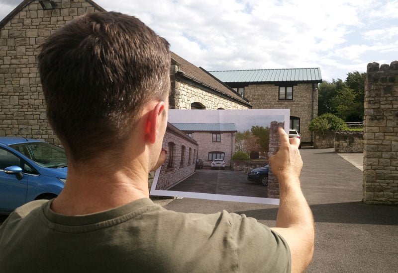
Type 3: Photomontage / Photowire


The definition of the Type 3 visualisation generally relates to what many will consider is a traditional digital photomontage. It provides an option where the image cannot be fully ‘verifiable’ or where the level of accuracy provided by a Type 4 visualisation is not required.
Type 3 visualisations can be prepared with many of the techniques used to produce a Type 4 image. However, they provide greater flexibility on preparing an image to help convey the image and feel of a development, without being scale verifiable.
Type 4: Photomontage / Photo-wire – Survey / Scale Verifiable


A Type 4 visualisation provides the most accurate representation of any development proposal. They are prepared in accordance with already established ‘verified’ / ‘verifiable’ image methodologies (e.g. ‘London View Management Framework‘; Scottish Natural Heritage’s ‘Visual Representation of Wind Farms‘). Careful consideration is needed on selecting the most appropriate methodology depending on the location and nature of development.


Type 4 images are most often prepared for developments in sensitive locations, or where specific issues of visual impact are identified as important to the decision-making process and require the highest level of accuracy and survey data provision.
All Type 4 images should be prepared and reproduced, with methodologies provided, such that third parties can verify the scale, and replicate the visualisation if they wish to do so. Therefore, Type 4 images provide the viewer with the confidence that the visualisation is an accurate representation of the image.
Scale representation of visualisations
TGN 06-19 simplifies how visualisations should be presented and viewed. It promotes the use of quality techniques and equipment to discourage images being presented with distortion or at too small a scale.
The key recommendation is that ideally the reproduction of a visualisation should be at a size suitable for ‘scale representation’ when viewed at ‘arm’s length’. In practice, this can be achieved with the use of a single photograph image, taken with a suitable camera, using a 50mm lens, reproduced at A3 (390 x 260mm) paper size, and viewed at approximately 540mm.
When such a reproduction is not possible, the guidance provides alternative methods, including when the use of wide-angle lenses may be suitable, such as for tall buildings in local urban contexts.
Conclusion
The new guidance is comprehensive, informative and, in part, educational. It provides a wealth of guidance and technical detail, providing the basis for preparing consistent visualisations for a wide range of situations. The guidance will assist those involved in preparing, assessing and determining Planning Applications and Appeals and describes the most appropriate production techniques and uses for visualisation types.
The phrase, a picture paints a thousand words, is appropriate to mention. With the application of this guidance to planning processes, all stakeholders involved in the development process should be better equipped to gain an understanding and appreciation of the effects of proposed development projects.
For advice on how the application of the new guidelines may affect your project, or to discuss a project need, please contact Chris Hale or one of our Visualisation Team on 01225 876990.