Avon Fire and Rescue Service needed a modernised fire station to replace their existing facility in central Bath. Nicholas Pearson Associates was commissioned to provide Landscape and Visual Impact Assessment (LVIA) and visualisation support to help the client understand how the proposed redevelopment would relate to the city’s twice‑designated World Heritage Site and Bath Conservation Area. We produced Verifiable Visual Montages (VVMs) to show how the revised building form would appear in key public views. Collaboration with BDP and the wider team ensured that landscape and townscape matters were integrated into the planning submission. Our work assisted the Local Planning Authority in reviewing the proposals using clear and verifiable evidence.
We applied established Landscape Institute guidance to structure the LVIA, ensuring clarity, proportionality and consistency across the assessment. The approach included verification photography, survey control and calibrated camera alignment to produce accurate VVMs that explained how the new facility would appear in representative public viewpoints. We coordinated closely with BDP [insert hyperlink: URL not supplied] to understand design changes, responding quickly to massing, elevation and material refinements so that all visual outputs remained technically aligned. Collaboration with JLL and BBHC ensured that landscape, visual and heritage considerations formed a coherent planning narrative. This process maintained methodological integrity whilst meeting a programme that required iterative updates and careful control of baseline and model accuracy.

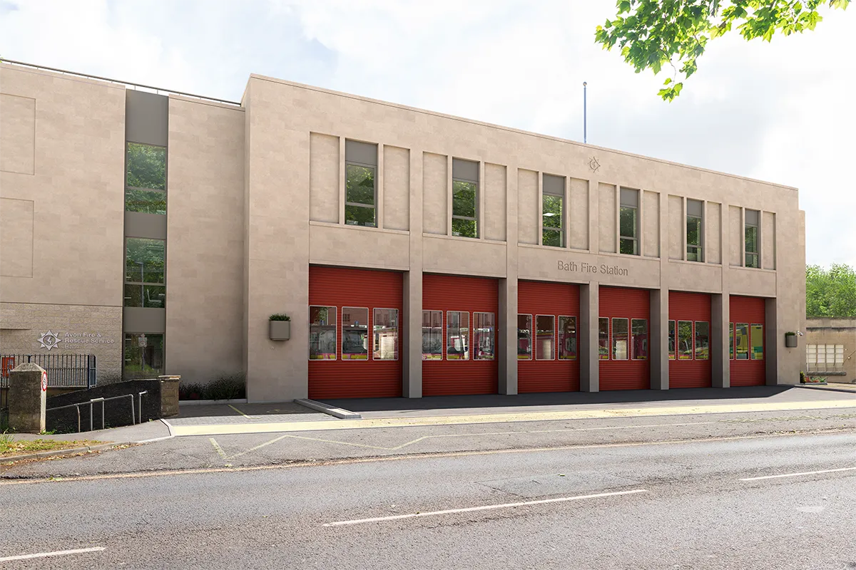
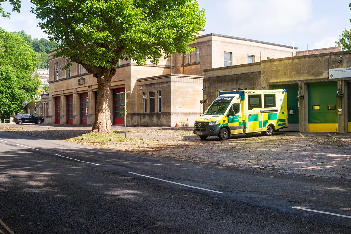
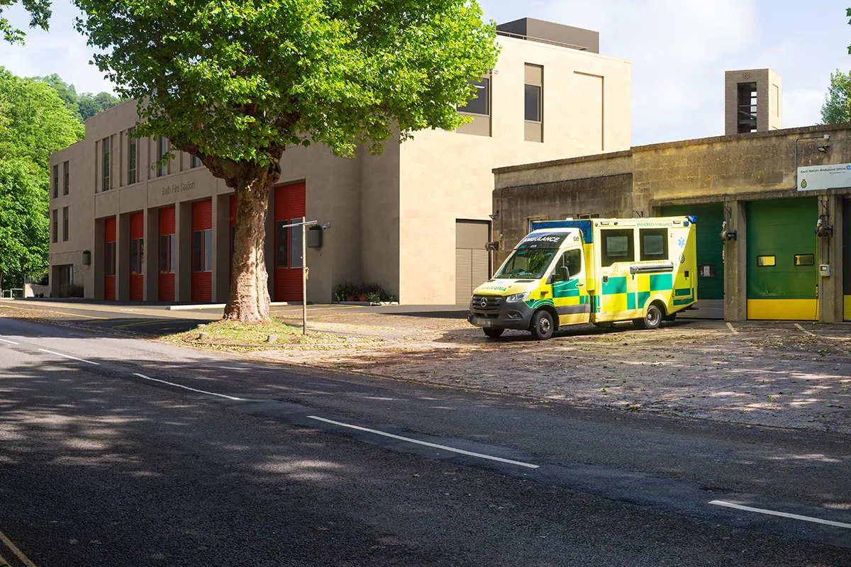
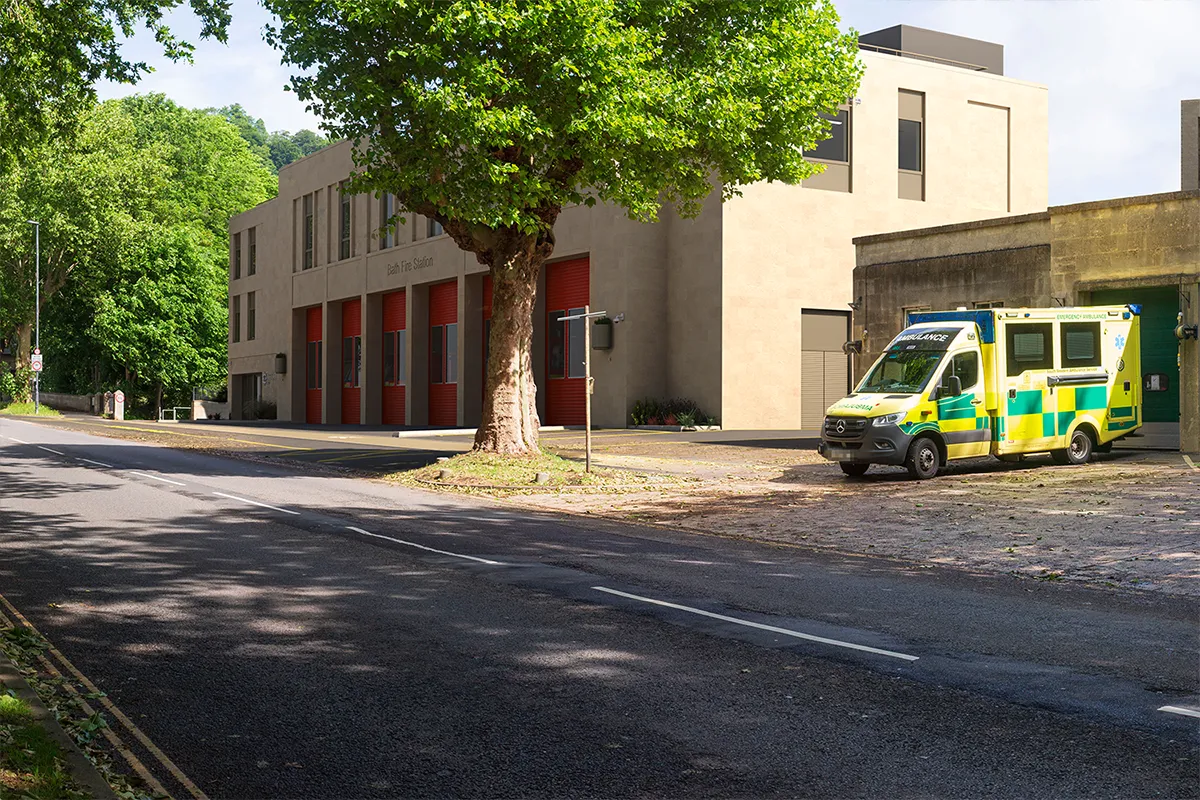
We delivered a LVIA supported by verifiable visualisations that provided a clear understanding of how the redeveloped fire station would affect local character and visual receptors. The LVIA identified appropriate viewpoints across Bath, including locations that illustrated the scale relationship between the proposed building and its surroundings. The assessment described townscape context, visual sensitivity and likely effects, allowing the Local Planning Authority to review and understand the proposals and the related effects with clarity. The VVMs illustrated the built form within the existing context, showing how massing and architectural treatment responded to local character and affected important views. This helped highlight where visual change would be limited and where it would be more noticeable.
We ensured that the assessment aligned with the heritage appraisal prepared by BBHC creating a coordinated suite of documents for the planning submission. The work enabled the planning authority to balance the planning needs of the emergency service and its operations with the nature of change to the sensitivities of Bath’s historic environment.
Clear communication shaped how the assessment supported engagement with the Local Planning Authority. The LVIA presented transparent reasoning on viewpoint selection, significance and likely effects. The VVMs assisted officers and consultees by offering verifiable and comparable imagery across design iterations. These materials improved understanding of how massing adjustments and façade changes affected key views. Close coordination with JLL ensured that the landscape and visual assessment integrated with the broader planning submission. The project obtained planning consent following the submission of this coordinated package. The project team representative commented: “Really appreciate the timescales you have turned this around in, thank you. A really thorough and informative report.”
Planning approval was granted, supported by clear LVIA findings and visualisations that enabled the Local Planning Authority to review the proposals within a sensitive historic setting. The project team benefited from a coordinated assessment that aligned landscape, visual and heritage considerations. The visual material demonstrated the effects of the redevelopment accurately, giving decision‑makers reliable information to consider the scheme. The project team representative acknowledged the responsiveness and thoroughness of the work. The final outputs formed an essential component of a robust and well‑supported planning submission for this important operational facility.
Please contact us to discuss how our team can help you with your next project.
Our values and value-led approach to Environmental Design help you to achieve your project’s potential We get to know our clients and provide pragmatic guidance and design solutions We can be [...]
Read moreOur value-driven approach to Landscape Architecture is designed to help you realise your project’s full potential We take the time to understand your goals and provide tailored design solutions [...]
Read moreOur ecologists will help you understand the biodiversity potential of your site We will get to know your site and build a consultancy relationship that you can depend on Our ecological site surveys [...]
Read moreOur talented team will help you to understand your site’s potential and visualise it’s development opportunities We can provide you with a range of photographic and digital services to suit your [...]
Read more
Legal & General Investment Management on behalf of London & Oriental needed to refurbish 38...

Project Introduction Branna Limited needed professional townscape assessment expertise as part of a...
Understanding Heritage Impact in Bristol’s Gateway 33 Horsefair Limited sought planning...
Deeley Freed and LaSalle Investment Management needed to secure planning approval for a major...
Please contact us to discuss how our landscape architecture team can help you with your next project.
Read more

